Camarillo, California
Appearance
Camarillo, California | |
|---|---|
|
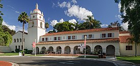
Clockwise: California State University Channel Islands; view of Camarillo; Mary Magdalene Chapel | |
| Motto(s): "Las Personas Son la Ciudad" ("The People Are the City") | |
 Location of Camarillo in Ventura County, California | |
| Coordinates: 34°14′N 119°2′W / 34.233°N 119.033°W | |
| Country | United States |
| State | California |
| County | Ventura |
| Rail station | 1898 |
| Incorporated | October 22, 1964[1] |
| Named for | Adolfo and Juan Camarillo |
| Area | |
| • Total | 19.70 sq mi (51.03 km2) |
| • Land | 19.69 sq mi (50.99 km2) |
| • Water | 0.02 sq mi (0.04 km2) |
| Elevation | 177 ft (54 m) |
| Population | |
| • Total | 70,741 |
| • Density | 3,593/sq mi (1,387/km2) |
| Time zone | UTC−8 (PST) |
| • Summer (DST) | UTC−7 (PDT) |
| ZIP Codes | 93010–93012[5] |
| Area code | 805 |
| FIPS code | 06-10046 |
| GNIS feature IDs | 1652682, 2409966 |
| Website | www |
Camarillo (/ˌkæməˈriːoʊ/ KAM-ə-REE-oh) is a city in Ventura County in the U.S. state of California. As of the 2020 United States Census, the population was 70,741.[4]
References
[change | change source]- ↑ "California Cities by Incorporation Date". California Association of Local Agency Formation Commissions. Archived from the original (Word) on November 3, 2014. Retrieved August 25, 2014.
- ↑ "2020 U.S. Gazetteer Files". United States Census Bureau. Retrieved October 30, 2021.
- ↑ "Camarillo". Geographic Names Information System. United States Geological Survey. Retrieved October 20, 2014.
- ↑ 4.0 4.1 "QuickFacts: Camarillo city, California". U.S. Census Bureau. Retrieved July 30, 2023.
- ↑ "ZIP Code(tm) Lookup". United States Postal Service. Retrieved November 7, 2014.


